

Post by coolplanet on Jul 11, 2014 13:13:56 GMT -5
Poor man’s polar vortex to make shocking summer return in eastern U.S. next week

By Jason Samenow | July 10, 2014
www.washingtonpost.com/blogs/capital-weather-gang/wp/2014/07/10/poor-mans-polar-vortex-to-make-shocking-summer-return-in-eastern-u-s-next-week/?Post%20generic=%3Ftid%3Dsm_twitter_washingtonpost
Call it the ghost of the polar vortex, the polar vortex sequel, or the polar vortex’s revenge. Meteorological purists may tell you it’s not a polar vortex at all. However you choose to refer to the looming weather pattern, unseasonably chilly air is headed for parts of the northern and northeastern U.S at the height of summer early next week.
Bearing a haunting resemblance to January’s brutally cold weather pattern, a deep pool of cool air from the Gulf of Alaska will plunge into the Great Lakes early next week and then ooze towards the East Coast.

Of course, this is July, not January, so temperatures forecast to be roughly 10 to as much as 30 degrees below average won’t have quite the same effect.
But make no mistake, in parts of the Great Lakes and Upper Midwest getting dealt the chilliest air, hoodies and jeans will be required. Highs in this region could well get stuck in the 50s and 60s – especially where there is considerable cloud cover.
Wednesday morning’s lows may drop into the 40s over a large part of the central U.S. Remember, this is July!
The heart of the chilly airmass will probably just skirt the East Coast, but temperatures are likely to be about 10 degrees below normal. Highs may struggle to reach 80 in D.C. next Tuesday and Wednesday with widespread lows in the 50s (even 40s in the mountains).
(Note, as with any extended forecast, there is some uncertainty here. If the cool air mass loses some punch, highs may still reach 80-85 around D.C., with lows in the 60s, rather than the 50s)
The pattern may last only a few days, but will probably set some records, especially around the Plains and Great Lakes – where water temperatures are still depressed from the frigid winter in which ice remained on Lake Superior into June.
What’s behind this unusual winter weather pattern primed for the dog days of summer? A lot of it is simply chance (randomness), but Weather Underground’s meteorologist Jeff Masters says Japan’s typhoon Neoguri is playing a role in the pattern’s evolving configuration:
“….the large and powerful nature of this storm has set in motion a chain-reaction set of events that will dramatically alter the path of the jet stream and affect weather patterns across the entire Northern Hemisphere next week. Neoguri will cause an acceleration of the North Pacific jet stream, causing a large amount of warm, moist tropical air to push over the North Pacific. This will amplify a trough low pressure over Alaska, causing a ripple effect in the jet stream over western North America, where a strong ridge of high pressure will develop, and over the Midwestern U.S., where a strong trough of low pressure will form.”
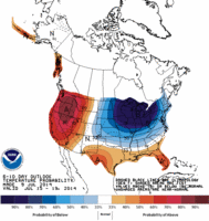
What amazes me most about the pattern is not so much the forecast temperatures, but the uncanny similarities in the weather patterns over North America seen in both the heart of winter and heart of summer. All of the same features (refer to the map at the top of this post) apparent in January are on the map in mid-July: low pressure over the Aleutians (blue shading), a large hot ridge (yellow and red shading) over the western U.S., the huge cold low or vortex over the Great Lakes (blue and green shading), and then the ridge over northeast Canada (yellow and red shading).
It’s not at all clear what this means or what, if anything, it portends. Weather patterns cycling through a certain circulation regime can repeat (and we’ve seen this pattern multiple times since November-December), but with El Nino forecast to develop, the global configuration of weather systems is likely to change.
More at link: www.washingtonpost.com/blogs/capital-weather-gang/wp/2014/07/10/poor-mans-polar-vortex-to-make-shocking-summer-return-in-eastern-u-s-next-week/?Post%20generic=%3Ftid%3Dsm_twitter_washingtonpost

By Jason Samenow | July 10, 2014
www.washingtonpost.com/blogs/capital-weather-gang/wp/2014/07/10/poor-mans-polar-vortex-to-make-shocking-summer-return-in-eastern-u-s-next-week/?Post%20generic=%3Ftid%3Dsm_twitter_washingtonpost
Call it the ghost of the polar vortex, the polar vortex sequel, or the polar vortex’s revenge. Meteorological purists may tell you it’s not a polar vortex at all. However you choose to refer to the looming weather pattern, unseasonably chilly air is headed for parts of the northern and northeastern U.S at the height of summer early next week.
Bearing a haunting resemblance to January’s brutally cold weather pattern, a deep pool of cool air from the Gulf of Alaska will plunge into the Great Lakes early next week and then ooze towards the East Coast.

Of course, this is July, not January, so temperatures forecast to be roughly 10 to as much as 30 degrees below average won’t have quite the same effect.
But make no mistake, in parts of the Great Lakes and Upper Midwest getting dealt the chilliest air, hoodies and jeans will be required. Highs in this region could well get stuck in the 50s and 60s – especially where there is considerable cloud cover.

Wednesday morning’s lows may drop into the 40s over a large part of the central U.S. Remember, this is July!
The heart of the chilly airmass will probably just skirt the East Coast, but temperatures are likely to be about 10 degrees below normal. Highs may struggle to reach 80 in D.C. next Tuesday and Wednesday with widespread lows in the 50s (even 40s in the mountains).
(Note, as with any extended forecast, there is some uncertainty here. If the cool air mass loses some punch, highs may still reach 80-85 around D.C., with lows in the 60s, rather than the 50s)
The pattern may last only a few days, but will probably set some records, especially around the Plains and Great Lakes – where water temperatures are still depressed from the frigid winter in which ice remained on Lake Superior into June.
What’s behind this unusual winter weather pattern primed for the dog days of summer? A lot of it is simply chance (randomness), but Weather Underground’s meteorologist Jeff Masters says Japan’s typhoon Neoguri is playing a role in the pattern’s evolving configuration:
“….the large and powerful nature of this storm has set in motion a chain-reaction set of events that will dramatically alter the path of the jet stream and affect weather patterns across the entire Northern Hemisphere next week. Neoguri will cause an acceleration of the North Pacific jet stream, causing a large amount of warm, moist tropical air to push over the North Pacific. This will amplify a trough low pressure over Alaska, causing a ripple effect in the jet stream over western North America, where a strong ridge of high pressure will develop, and over the Midwestern U.S., where a strong trough of low pressure will form.”
What amazes me most about the pattern is not so much the forecast temperatures, but the uncanny similarities in the weather patterns over North America seen in both the heart of winter and heart of summer. All of the same features (refer to the map at the top of this post) apparent in January are on the map in mid-July: low pressure over the Aleutians (blue shading), a large hot ridge (yellow and red shading) over the western U.S., the huge cold low or vortex over the Great Lakes (blue and green shading), and then the ridge over northeast Canada (yellow and red shading).
It’s not at all clear what this means or what, if anything, it portends. Weather patterns cycling through a certain circulation regime can repeat (and we’ve seen this pattern multiple times since November-December), but with El Nino forecast to develop, the global configuration of weather systems is likely to change.
More at link: www.washingtonpost.com/blogs/capital-weather-gang/wp/2014/07/10/poor-mans-polar-vortex-to-make-shocking-summer-return-in-eastern-u-s-next-week/?Post%20generic=%3Ftid%3Dsm_twitter_washingtonpost